Saturday, January 20, 2007

Saturn's Hyperion


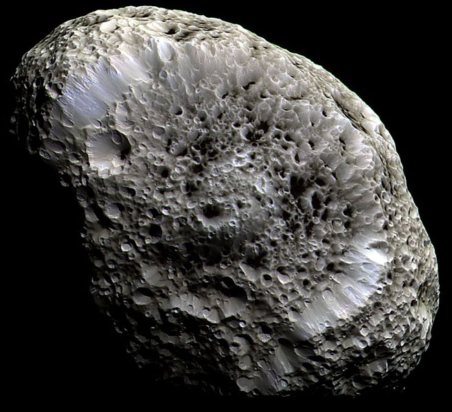
What lies at the bottom of Hyperion's strange craters? Nobody knows. To help find out, the robot Cassini spacecraft now orbiting Saturn swooped past the sponge-textured moon again last week and took an image of unprecedented detail. That image, shown above in false color, shows a remarkable world strewn with strange craters and a generally odd surface. The slight differences in color likely show differences in surface composition. At the bottom of most craters lies some type of unknown dark material. Inspection of the image shows bright features indicating that the dark material might be only tens of meters thick in some places. Hyperion is about 250 kilometers across, rotates chaotically, and has a density so low that it might house a vast system of caverns inside.

Monster Bunnies For North Korea

An east German pensioner who breeds rabbits the size of dogs has been asked by North Korea to help set up a big bunny farm to alleviate food shortages in the communist country. Now journalists and rabbit gourmets from around the world are thumping at his door.

It all started when Karl Szmolinsky won a prize for breeding Germany's largest rabbit, a friendly-looking 10.5 kilogram (23 lbs) "German Gray Giant" called Robert, in February 2006.

Images of the chubby monster went around the world and reached the reclusive communist state of North Korea, a country of 23 million which according to the United Nations Food Programme suffers widespread food shortages and where many people "struggle to feed themselves on a diet critically deficient in protein, fats and micronutrients."

source: spiegel.de

How Can We Convert the US to the Metric System?


Despite past efforts of the 1970s and 1980s, the United States remains one of only three countries (others are Liberia and Myanmar) that does not use the metric system. Staying with imperial measurements has only served to handicap American industry and economy. Attempts to get Americans using the Celsius scale, or putting up speed limits in kilometers per hour have been squashed dead. Not only that, but some Americans actually see metrication efforts as an assault on 'our way' of measuring.

Winter Weather Across the United States


A powerful winter storm swept across the United States on January 15 and January 16, 2007, leaving much of the country under snow and ice. The storm moved from northern Texas, across the Midwest, and into the Northeast. By January 16, when the Moderate Resolution Imaging Spectroradiometer (MODIS) on NASA’s Aqua satellite captured this image, the clouds cleared enough to reveal a path of snow across the Midwest. The Intermountain West was also buried in a blanket of white snow, but the Southeast and the East were still covered by a broad band of clouds. More winter weather swamped the Midwest in the days that followed. By January 19, icy roads and other weather-related incidents had claimed 70 lives, reported CNN.

This image of the United States was stitched together from three satellite overpasses. Faint diagonal lines across the image reveal the boundary between each image. The large image provided above has a resolution of one kilometer per pixel.

NASA image courtesy the MODIS Rapid Response Team at NASA GSFC.

An Unlikely Alliance


Environmental Woes: A lignite-fired power plant spews smoke over the German village of Gusdorf

By Samantha Henig
Newsweek
Updated: 11:13 a.m. CT Jan 17, 2007

Jan. 17, 2007 - A group of 28 scientists and evangelical Christians today announced their commitment to working together to address global and environmental climate change--an issue that they say is pressing enough to trump any theological differences between the groups. Eric Chivian, director of the Center for Health and the Global Environment at Harvard Medical School, is one of the scientists leading the collaboration. In an interview with NEWSWEEK’s Samantha Henig, Chivian discussed the origins of this peculiar union, what the two groups have in common, how the evangelical Christian community can help scientists and the spiritual significance of his fruit garden. Excerpts:

NEWSWEEK: Scientists and evangelicals have announced that they are coming together to address global warming and environmental change. What exactly does this collaboration entail?
Eric Chivian:
We believe that it was very important for these two groups--scientists and evangelical Christians--to get together and speak with one voice, because the public sees us as disagreeing on a whole variety of issues. And yet it was clear after we began to meet that we really shared a very deep reverence for life and we shared an enormous concern about what was being done to it by human activity. And that was a surprise to us.

What do you have planned?
We are planning to meet with a bipartisan group of members of the Congress this afternoon. I know we’re meeting with Sen. Barbara Boxer and with the staff of Sen. Dick Lugar, and others in both the House and Senate. We are planning a large meeting some time in the near future of our two communities, a large public meeting. This is just the beginning of this dialogue.

Chivian, environment

Who are the scientists working on this? Are any of them members of the National Association of Evangelicals?
Some in the evangelical group are also scientists. For example, Cal Dewitt is a professor of environmental science at the University of Wisconsin, but he’s also a prominent evangelical. Randy Isaac is a scientist who runs something called the American Scientific Affiliation, which is a group of some 2,000 scientists, most of whom are evangelicals, but are also scientists. So this distinction between scientist and evangelical is not a firm one.

It seems like an unlikely pairing, evangelicals and scientists.
Yes, it does.

continue @ newsweek


Friday, January 19, 2007

Cold War era military artwork from the Military Art Collection of the United States Defence Intelligence Agency (DIA)


See Full Gallery @ militaryphotos.net

On Approach: Jupiter and Io

This image was taken on Jan. 8, 2007, with the New Horizons Long Range Reconnaissance Imager (LORRI), while the spacecraft was about 81 million kilometers (about 50 million miles) from Jupiter. Jupiter's volcanic moon Io is to the right; the planet's Great Red Spot is also visible. The image was one of 11 taken during the Jan. 8 approach sequence, which signaled the opening of the New Horizons Jupiter encounter.

Even in these early approach images, Jupiter shows different face than what previous visiting spacecraft - such as Voyager 1, Galileo and Cassini - have seen. Regions around the equator and in the southern tropical latitudes seem remarkably calm, even in the typically turbulent "wake" behind the Great Red Spot.

The New Horizons science team will scrutinize these major meteorological features - including the unexpectedly calm regions - to understand the diverse variety of dynamical processes on the solar system's largest planet. These include the newly formed Little Red Spot, the Great Red Spot and a variety of zonal features.

Credit: NASA/Johns Hopkins University Applied Physics Laboratory/Southwest Research Institute.

Expert Wants to Decertify Global Warming Skeptics

Apparently in the Senate, at least one scientist wants to put a permanent stop to any arguments over Global Warming. The Weather Channel's most prominent climatologist is advocating that broadcast meteorologists be stripped of their scientific certification if they express skepticism about predictions of manmade catastrophic global warming.

The First HD DVD Movie Hits BitTorrent

Ars Technica reports that the first HD DVD movie has made its way onto BitTorrent, showing that current DRM efforts to prevent illegal sharing of copyrighted content are still futile and fighting an uphill battle. From the article: "The pirates of the world have fired another salvo in their ongoing war with copy protection schemes with the first release of the first full-resolution rip of an HD DVD movie on BitTorrent. The movie, Serenity, was made available as a .EVO file and is playable on most DVD playback software packages such as PowerDVD. The file was encoded in MPEG-4 VC-1 and the resulting file size was a hefty 19.6 GB."

Global Warming Exposes New Islands in the Arctic

LIVERPOOL LAND, Greenland — Flying over snow-capped peaks and into a thick fog, the helicopter set down on a barren strip of rocks between two glaciers. A dozen bags of supplies, a rifle and a can of cooking gas were tossed out onto the cold ground. Then, with engines whining, the helicopter lifted off, snow and fog swirling in the rotor wash.

When it had disappeared over the horizon, no sound remained but the howling of the Arctic wind.

“It feels a little like the days of the old explorers, doesn’t it?” Dennis Schmitt said.

Mr. Schmitt, a 60-year-old explorer from Berkeley, Calif., had just landed on a newly revealed island 400 miles north of the Arctic Circle in eastern Greenland. It was a moment of triumph: he had discovered the island on an ocean voyage in September 2005. Now, a year later, he and a small expedition team had returned to spend a week climbing peaks, crossing treacherous glaciers and documenting animal and plant life.

Despite its remote location, the island would almost certainly have been discovered, named and mapped almost a century ago when explorers like Jean-Baptiste Charcot and Philippe, Duke of Orléans, charted these coastlines. Would have been discovered had it not been bound to the coast by glacial ice.

Maps of the region show a mountainous peninsula covered with glaciers. The island’s distinct shape — like a hand with three bony fingers pointing north — looks like the end of the peninsula.

Now, where the maps showed only ice, a band of fast-flowing seawater ran between a newly exposed shoreline and the aquamarine-blue walls of a retreating ice shelf. The water was littered with dozens of icebergs, some as large as half an acre; every hour or so, several more tons of ice fractured off the shelf with a thunderous crack and an earth-shaking rumble.

All over Greenland and the Arctic, rising temperatures are not simply melting ice; they are changing the very geography of coastlines. Nunataks — “lonely mountains” in Inuit — that were encased in the margins of Greenland’s ice sheet are being freed of their age-old bonds, exposing a new chain of islands, and a new opportunity for Arctic explorers to write their names on the landscape.

“We are already in a new era of geography,” said the Arctic explorer Will Steger. “This phenomenon — of an island all of a sudden appearing out of nowhere and the ice melting around it — is a real common phenomenon now.”

full story: nytimes.com

The hidden engineering gender gap

By Joyce Park 01.2.07

(Editor’s note: This essay comes in two parts. Here is the first part.)

Anyone who has met John Doerr knows that he is genuinely passionate about encouraging the participation of women in the venture-creation system: as VCs, as entrepreneurs, and especially as engineers. He was the first person I ever heard clearly articulate something that I think many of us suspect in our hearts but are hesitant to say.

With all love and respect to our sisters in product management, marketing, sales, finance, HR, and G&A, 50 years of Silicon Valley history strongly suggest that technology companies will ever continue to be founded by entrepreneurs from engineering backgrounds; and if women never become engineers in sufficient numbers, they will disproportionately fail to experience the upper end of the range of Silicon Valley outcomes.

Furthermore, it’s impossible to calculate the opportunity cost to Silicon Valley ventures due to insufficient diversity of backgrounds, ideas, and modes of thought; but as the end consumer of our work becomes increasingly female, these costs must be rising.

However, no one can have failed to notice that despite all the efforts of a great many fearsomely brilliant, motivated, and determined individuals and groups to support women — Mr. Doerr and a few other funders, the Anita Borg Institute, Google and Yahoo and HP, Mills College and Stanford and Berkeley — there are still not nearly as many working female engineers as male.

And when it comes to female tech entrepreneurs from an engineering background I believe the ratio is even more skewed, although no one seems to even know a definitive number. Finally, when you count the women who head venture-backed businesses — which is an utterly arbitrary distinction except insofar as it highlights the availability of capital and other resources which can ease the crushing burden of starting a business — it is a lonely little group indeed.

But I’m not here to wring my hands and whine about the status quo. Nor do I plan to propose computer science education as the long-term solution to the gender imbalance problem, because far better-qualified people than I are already working along those lines. Instead I want to focus on a well-known but little-studied phenomenon in the technology industry — particularly in the newer, more experimental, startup-driven subdomains — and in the Open Source movement. This enigma is the lack of self-taught female software engineers. (Throughout this essay, by “self-taught” I mean someone who lacks a degree in computer science and has taken personal responsibility for training him or her self as a software engineer. Some of them may have enjoyed on-the-job training or other instruction, even including non-degree-granting university-level instruction, but in my mind they still count as self-directed.)

Everyone in professional or Open Source software development has worked with countless male colleagues who are essentially self-taught, lacking all or most formal training in computer science, and in not a few cases bereft of any post-secondary degree whatsoever. In the perhaps less glamorous areas of the software development lifecycle — QA, build and release, documentation, i18n, metrics, DBA, etc. — almost everyone I’ve ever worked with has lacked formal qualifications (which in many cases don’t exist anyway). These self-motivated male engineers run the gamut of quality, from the best of the best to the truly sub-par; but it is incontestable that there are a relatively large number of them, and that they form an important part of the technology ecosystem. But everyone seems to agree — and certainly it has been my experience — that there is no correspondingly large pool of female professional and Open Source engineers without formal training.

Why does this gender gap in non-CS-degreed software engineers exist? Could it be bridged through some sort of organized effort? Would such an effort be ethically troubling or bad for the profession in some other way? What opportunities might be lost if we continue to do nothing about the gender disparity in software engineering, or simply wait for long-term educational efforts to take root at some unspecified future date? For those who care about women in the technology industry, I would argue that these questions should be very pressing and our ignorance of their answers should be equally troubling.

(Joyce proposes an answer to these last questions in Part Two: A modest proposal.)

Real Life Car Pinball

Monday, January 15, 2007

Comet McNaught via SOHO Satellite

This is an animation of the most recent images from the SOHO spacecraft's LASCO C3 camera.

Expect it to load slowly

Comet C/2006 P1 (McNaught) will be visible from Friday, Jan. 12 to Monday, Jan. 15. The first SOHO images of the comet can be seen in our Comet McNaught Viewer's Guide.

This real-time movie, which shows the most recent 48 hours of solar activity, is updated every hour if satellite communications permit. The image is generated by the Solar and Heliospheric Observatory (SOHO) spacecraft.

Other animation sizes and formats are avaible at the SOHO site.

Instruments on SOHO makes images like this one by blocking the light coming directly from the Sun with an occulter disk, creating an artificial eclipse within the instrument itself. The lack of detail (notice that the tail is all white) occurs because the comet is so bright it saturates the image detector. The small moving dot is Mercury.

SOHO is a project of international cooperation between ESA and NASA.

More SPACE.com Cams

Comet McNaught Over Catalonia, Spain


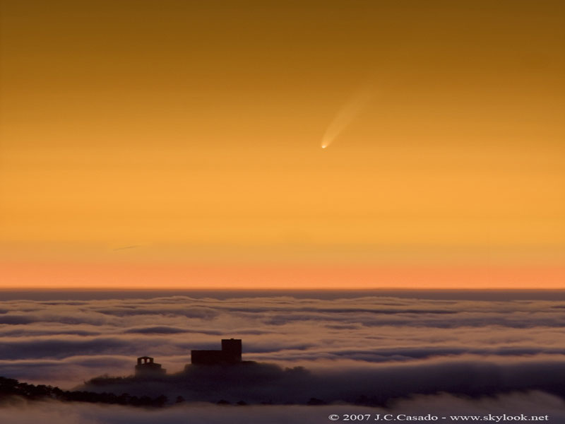
This past weekend Comet McNaught peaked at a brightness that surpassed even Venus. Fascinated sky enthusiasts in the Earth's northern hemisphere were treated to an instantly visible comet head and a faint elongated tail near sunrise and sunset. Recent brightness estimates had Comet McNaught brighter than magnitude -5 (minus five) over this past weekend, making it the brightest comet since Comet Ikeya-Seki in 1965, which was recorded at -7 (minus seven). The Great Comet of 2007 reached its brightest as it rounded the Sun well inside the orbit of Mercury. Over the next week Comet McNaught will begin to fade as it moves south and away from the Sun. The unexpectedly bright comet should remain visible to observers in the southern hemisphere with unaided eyes for the rest of January. The above image, vertically compressed, was taken at sunset last Friday from mountains above Catalonia, Spain.

Friday, January 12, 2007

How Not to Parallel Park

Pillars of Creation


This majestic view, taken by NASA's Spitzer Space Telescope, tells an untold story of life and death in the Eagle Nebula, an industrious star-making factory located 7,000 light-years away in the Serpens Sonstellation. The image shows the region's entire network of turbulent clouds and newborn stars in infrared light.

The color green denotes cooler towers and fields of dust, including the three famous space pillars, dubbed the "Pillars of Creation," which were photographed by NASA's Hubble Space Telescope in 1995 (right of center; see http://www.nasa.gov/mission_pages/spitzer/multimedia/ssc2007-01b.html for exact location).

But it is the color red that speaks of the drama taking place in this region. Red represents hotter dust thought to have been warmed by the explosion of a massive star about 8,000 to 9,000 years ago. Since light from the Eagle Nebula takes 7,000 years to reach us, this supernova explosion would have appeared as an oddly bright star in our skies about 1,000 to 2,000 years ago.

According to astronomers' estimations, the explosion's blast wave would have spread outward and toppled the three pillars about 6,000 years ago (which means we wouldn't witness the destruction for another 1,000 years or so). The blast wave would have crumbled the mighty towers, exposing newborn stars that were buried inside, and triggering the birth of new ones.

source: nasa.gov

Thursday, January 11, 2007

10th Annual Wacky Warning Label Contest

It's official: M-Law's 10th Annual Wacky Warning Label Contest is over. First prize has gone to a washing machine label urging not to put people in washers. Started to promote awareness of excessive litigation, the contest highlights common sense warning labels, such as the one that warns not to dry cellphones in microwave ovens. Companies find it necessary to stick crazy warnings on their products because of previous insane lawsuits.

NASA Finally Goes Metric

"Space.com is reporting that NASA has decided to use the metric system for its new lunar missions. NASA hopes that metrication will allow easier international participation and safer missions. The loss of the Mars Climate Orbiter was blamed on an error converting between English units and metric units. 'When we made the announcement at the meeting, the reps for the other space agencies all gave a little cheer,' said a NASA official."

source: space.com

Monday, January 08, 2007

Home Project - Closet

installed my hang-track and standards today. did you know Home Depot refuses to cut hang-track? they only cut shelving... so i bought a $4 hack-saw and cut it myself. somehow i managed to find two studs in the wall... it's a miracle! long-story short, the developer of my condo didn't put studs every 16" inches. in addition to the two studs, i also used two 50 pound dry-wall anchors. after drilling holes in the hang-track and some pilot holes in the studs, mounting was a breeze. standards just snap in... here's what it looks like.


now the fun part... figuring out what shelves, drawers, etc to put in...

Sunday, January 07, 2007

Dazzling Dunes

Endurance Crater
As NASA's Mars Exploration Rover Opportunity creeps farther into "Endurance Crater," the dune field on the crater floor appears even more dramatic. This false-color image taken by the rover's panoramic camera shows that the dune crests have accumulated more dust than the flanks of the dunes and the flat surfaces between them. Also evident is a "blue" tint on the flat surfaces as compared to the dune flanks. This results from the presence of the hematite-containing spherules, or "blueberries", that accumulate on the flat surfaces.

Sinuous tendrils of sand less than 1 meter (3.3 feet) high extend from the main dune field toward the rover. Scientists hope to send the rover down to one of these tendrils in an effort to learn more about the characteristics of the dunes. Dunes are a common feature across the surface of Mars, and knowledge gleaned from investigating the Endurance dunes may apply to similar dunes elsewhere.

Before the rover heads down to the dunes, rover drivers must first establish whether the slippery slope that leads to them is firm enough to ensure a successful drive back out of the crater. Otherwise, such hazards might make the dune field a true sand trap.

source: nasa.gov